


Arctic by Cycle: Arctic Post Road Gravel Route
 347 km
 5-7 days
 11341m
 477m
477m 34 %
34 % 0 %
0 % 3
3 100 %
100 %
The 347km and 5-7 day gravel version of the Arctic Post Road MTB Route is somewhat a modern take of its big brother as it uses some less used paved and gravel roads, instead of following the remnants of the old Copenhagen-Alta post road deep in the arctic tundra. To be fair, it barely even earns its name as a gravel route, as only 34 percent of the distance is on gravel and dirt roads. However, it still hits some of the best gravel roads, wilderness shelters, and camp spots on the way and in the Finnmark highland, completes the Kautokeino-Hetta postal 4×4 track, still having the spirit and soul of its hardcore, benchmark sibling.
The route was designed with a gravel rig in mind, making riding the route possible with any bike fitting a minimum of 40mm tires with whatever gear you happen to have strapped on your bike. As riding is relatively easy, the route flattish, and the services along the route are frequent and high quality, it’s also easy to hop service to service, making riding the route very comfy as well as e-bike friendly. The only drawback of the route is an 85km day on the main road of Hetta, Finland, and Kautokeino, Norway, and has traffic of lorries and RVs, but it’s a necessary evil to cross the Finnish-Norwegian border without a mountain bike. Apart from that, the paved roads are mostly low-traffic and relatively safe to ride.
Read more about what the route has to offer as well as our take on riding the route in the Trail notes below…
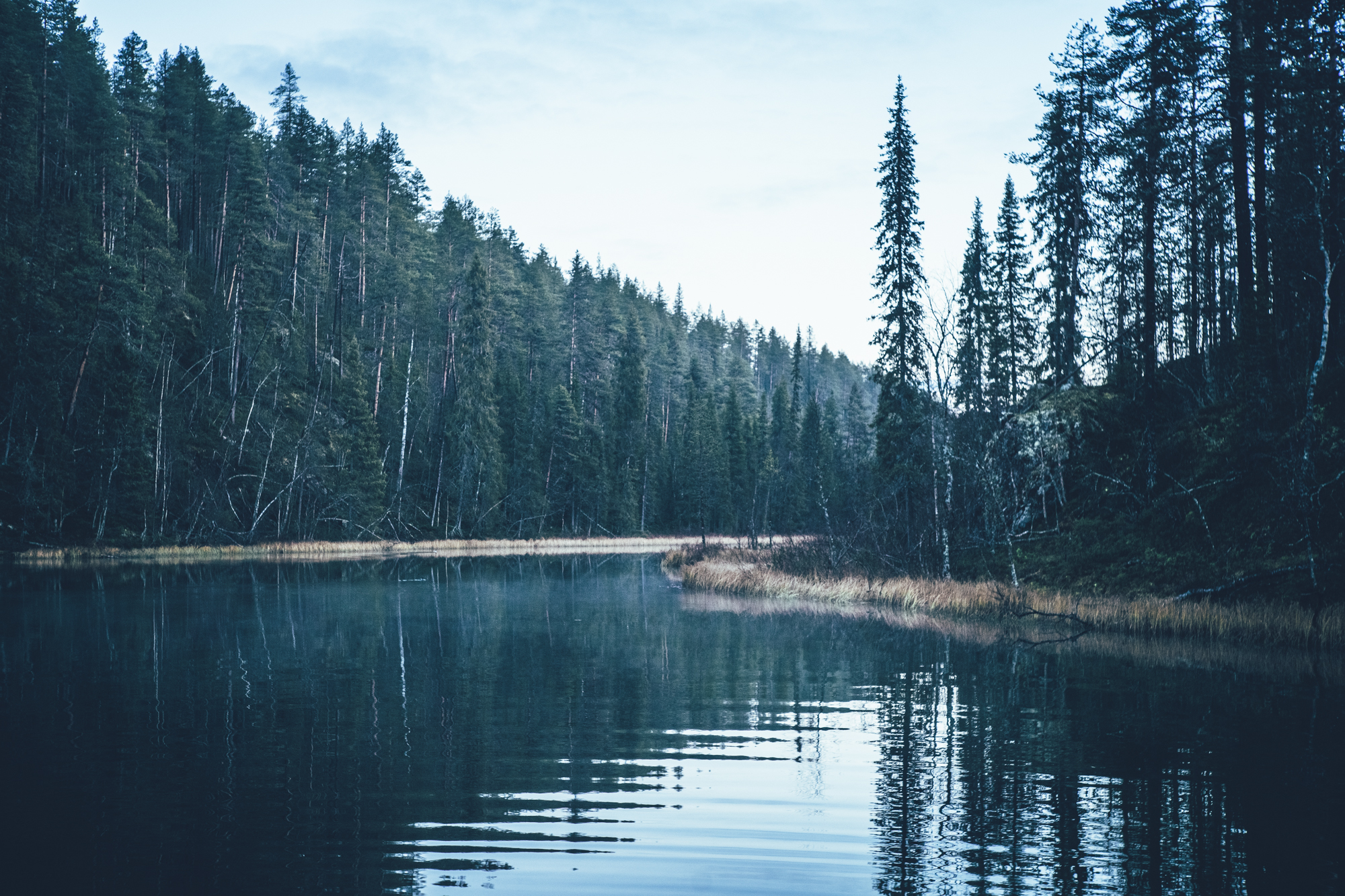
- Riding parallel to the line of fells of the Ylläs-Pallastunturi National Park on low-traffic back roads.
- Historic and scenic wilderness shelters along the route, giving shelter as well great spots to camp.
- High-quality frequent services, making hopping service to services possible across the route even with an e-bike.
- Cycling the old post road connecting from Kautokeino to the Alta valley.
- Arrival at the Arctic Ocean on the back roads and recreational gravel paths on the side of the Alta valley.
- Northern lights can be seen multiple times a week in autumn, if the sky is clear at night.
- The gravel routes in the arctic are usually open from early June after the routes have dried and hardened up after winter, to mid-October, when the winter sets in again. However, the climate crisis makes seasons more unpredictable than before so the season start and end can vary year to year by a couple of weeks
- The infamous arctic räkkä (the high population of mosquitos, black flies, biting midges and horse flies) starts usually by late June and lasts usually till mid August, making the early June or from mid-August till October ideal time to ride the route.
- The route can be ridden with any bike, as long as the tire size is a minimum of 40 mm and you also have smaller gears.
- The route can be toured with an e-Bike if your rig can handle the 75km rough section of road with 1200m of climbing between Kautokeino and Suolovuopmi.
- The route is not ideal to tour with a trailer or a wider rig as the old post road on Finnmarks highland is really rough riding, despite being a gravel road.
- Temperatures during the snowless season a lot and week-to-week but expect the spot-on daytime temperatures of 15-23 Celsius from mid-June to late August with nights in the range of 0-10 Celsius. Early June could be warm too but could be significantly colder as well. In late August and September, the temperatures start to drop significantly week by week and the first snow is not uncommon in late September. Especially late in the season, in late September and early October, be prepared for daytime temperatures of 5-10 Celsius and nights getting already below freezing.
- When choosing a sleeping bag, you should assume that the night temperatures can drop to 0 Celsius even during the mid-summer months and then even colder later the season gets. The classic -7 C/ 20 F sleeping bag works like a charm in Lapland, too, with the lower limit low enough for the late-season exploits.
- The midnight sun or “the nightless night” lasts from around 6 weeks in Southern Lapland to up to 3 months in Northern Norway. Getting used to the 24h sun can take a while to get used to…
- The best time to see the northern lights is roughly starting from September and as the nights get darker and longer towards the end of the season, chances are getting better week by week. It’s not uncommon to see the auroras multiple times a week at the end of the season, given that the weather gods are on your side and the sky is clear.
- The route has only digital navigation; for instructions and tips for successful navigation, see here.
- Always stay on the routes and aim to only use the recommended spots marked on the route map.
- The mobile phone network does not cover the whole route area: in case of an emergency, call 112 or use the 112 app, which automatically shares your location to the emergency services as well. It might be wise to carry a personal emergency beacon, especially when traveling alone.
- The route is located in a traditional reindeer herding area, please read more about the etiquette of traveling in the reindeer herding land here. Please respect any guidelines given for the route use or the use of reindeer herder’s cabins in the route description or on the map. Cooperation and respect for their needs and culture make having these routes publicly available possible.
- Bears, wolfs and wolverines are not an issue at all when wild camping as the arctic predators avoid human contact to all cost. There are practically no encounters, ever. Therefore, there is no need to have a bear bell on handlebars, bear safe food containers or hand your food in a tree for the night.
- The worst of the mosquito season lasts usually from around mid-June to late August, though luckily cycling speed is usually fast enough to keep them away when on the move. During the peak times, a net hat and long sleeve shirt and pants are recommended, if the temperatures allow. As the temperatures drop, the mosquitos disappear, making September (if not also early June, if the roads are dry enough) an ideal time for touring.
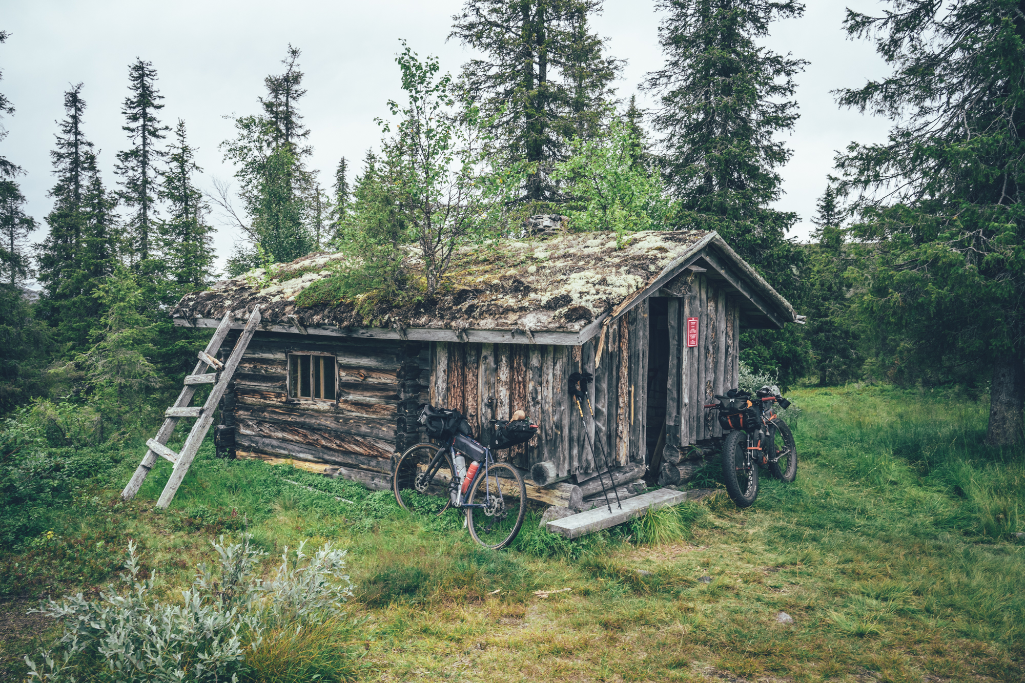
- There are 6 wilderness shelters along the way, which are the recommended camping spots on the route as well.
- Lodging is available frequently as well, also outside the villages
- Camping is allowed and free of charge along the route by All Man’s Rights in Finland and Norway, however, due to the fragile and slow-growing arctic flora, you should always aim to use only the campsites marked on the route map. Also, camping is strictly prohibited outside the recommended camp spot in the Ylläs-Pallastunturi National Park
- Open wilderness huts and other wilderness shelters are a treat, but the rules of use are strict to make the system work. The last to arrive has the priority to stay overnight, so make space for people arriving after you. All the near-by-surroundings of the wilderness shelters operate as official camping grounds, so the huts serve the most, and those the most in need, if you camp and use the hut only for cooking, socializing, and drying wet gear.
- All the camp spots are next to a high-quality water source unless stated otherwise.
- The grocery stores for restocking are located in Raattama, Hetta, Galdotieva and Kautokeino, and Maze, meaning you need to be able to carry just little more than one day's food on the route.
- There are restaurants or cafés available in Jerisjärvi, Pallas, Hetta, Galdotieva, Kautokeino and Suolovuopmi fjellstue
- Water is most of the time drinkable straight from streams, ponds, and lakes, but you never know if there is a reindeer carcass upstream, so better to be safe than sorry: water treatment is recommended.
- Sources of water are plentiful, so you’ll get away with carrying just 1-2 liters of water. The best spots for refills are marked on the route map.
- All the camp spots are next to a high-quality water source, unless stated otherwise - which is rare.
- Tap water is always drinkable in Finland and the locals are happy to fill your bottle
- When cooking in the camp, know that making a fire is strictly prohibited during the forest fire warming period. See the local restrictions here
- Compared to the MTB version of the Arctic Post Road, riding is easy. In terms of technical difficulty the route earns 4/10 and in terms of physical difficulty 5/10. Additionally, there are plenty of resupply points and wilderness shelters and you can get away with carrying just one day of food, giving the route a grade of 5/10 for the bikepacking challenge. Overall the route grants 5/10.
- The route was designed with a gravel rig in mind, making riding the route possible with any bike fitting a minimum of 40mm tires with whatever gear you happen to have strapped on your bike. As riding is relatively easy, the route flattish, and the services along the route are frequent and high quality, it’s also easy to hop service to service, making touring easy.
- Getting to Äkäslompolo
- There is an overnight train connection from Helsinki to Kolari (16 hours from Helsinki) multiple times a week, with often a bus connection to Äkäslompolo (Ylläs) to reach the starting point of the route. Though you can also do a short day on gravel to reach Äkäslompolo from the train station. You can book train tickets from vr.fi
- There are flights from Helsinki to Kittilä Airport multiple times a day and a short bus ride then takes you to Äkäslompolo where the route starts.
- You can also take a train or flight to Rovaniemi and then cycle half (270km) of the Santa's Western Grave Loop to Äkäslompolo.
- Bus connection to Äkäslompolo is still mostly non-existent, however there is daily-ish bus from Oulu/Tornio to Kolari, from where you can cycle the last 48km on the Santa's Western Grave Loop to Äkäslompolo. Some bus companies allow booking the bike spot in advance, but some don't, which means that they'll accept the bike onboard if it just fits in the cargo hold. Tickets and timetables from Matkahuolto website.
- Getting out from Alta
- If not returning to Finland, your options are:
- Fly out directly from Alta. The connection works but it is not as frequent as out from Tromsø, sometimes pricier too.
- Take a bus from Alta to Tromsø (7h) and fly out from there. It's a nice bus trip, so not a bad option. Spot for the bike though cannot be purchased in advance and it fits in if there is space. If you have time, you could get off that bus already at Lyngeidet (after the doing the Olderdalen -Lyngseidet ferry in the bus) and cycle the last 77km across Lyngen Alps to Tromsø. One ferry on the way (Svensby-Breidvik), so needs some planning timing wise though. 52km with low traffic and the last 25km is on the main road.
- Use the Hurtigruten ferry to reach Tromsø. Here the first option is to take either a bus (2.5h) or a ferry (2.5 h) from Alta to Hammerfest and from there get on the ferry (10 hours). The second option is to get on the Hurtigruten ferry is to cycle 120km to Øksfjord (80km along the main road with occasional side roads to avoid the traffic and then 50km with less traffic to Øksfjord) and catching the ferry to Tromsø from there (7h 40min). The ferry doesn't run every day, so this needs some planning in advance.
- If you are returning to Finland:
- Polar Star Travel offers cycle, person and goods transport between Kittilä (FIN) and Alta (NOR) and back between 10th of August 2024 – 28th of September 2024 every Saturday. Find more information about the connection from here.
- There is no other public transportation back to Äkäslompolo at the moment. Ideally, if you need to get back to Äkäslompolo and you have the time, ride the MTB route to Alta and then the gravel version back. There is a bus connection from Alta to Kautokeino, which shortens the way back a little, though on the Finnmarks highlands both versions of the route are not-to-miss.
- A bus connection back to Finland and the city of Rovaniemi. First take a bus from Alta to Karasjok (3h 15min) and then change a bus from Karasjok to Rovaniemi (8h 10min). The Karasjok-Rovaniemi bus does not go every day, so this connection needs some planning in advance. Tickets to Alta-Karasjok by are sold by Snelandia and the tickets to Karasjok-Rovaniemi bus are sold by Matkahuolto. There are multiple trains and flights from Rovaniemi to Helsinki on daily basis.
- Getting off the Rovaniemi bus at Pikku-Poikela and taking the Central Lapland Gravel Loop to Äkäslompolo is an option too. Kittilä Airport and further on the Kolari railway station are along the route. The section of Central Lapland Gravel Loop from Pikku-Poikela bust station to Äkäslompolo is 202km.
- Travelling by bus with a bike in Finnmark and Tromsø area
- The Finnmark and Tromsø area bus connections are coordinated by Snelandia. The tickets can be only bought through their phone app. The pricing is based on how many regions you travel through and the ticket validity starts immediately when you purchase the ticket. Spots for a bike cannot be booked in advance, unfortunately and the bikes fit only if there is space. Solo travellers get on the buses with a bike pretty easily, I've been told, but in a group of 2 or more you all might not fit on the same bus. Because of the risk of not getting on the bus due to lack of space, buy the ticket only when the driver has confirmed that there is space for your bike.
Day 1, Äkäslompolo village to Hotel Jeris & Sauna World (49km, 530m of climbing)
The route starts with an easy cruise out of the village on the paved road till reaching the Äkäsaivo spring lake and Äkäsaivo campfire hut (a little detour away though). From there, a narrow gravel road continues north alongside the National Park going by the tiny and old Pahtavuoma open wilderness hut around 30km from the start.
The rest of the day is easy riding as well, first on a fast lakeside gravel road and then on pavement toward the options for spending the night. The Arctic Sauna World with four different saunas at the Hotel Jeris is strategically located at the end of the day. Alternatively, the Hotel Pallas is only 8km further along the route as well and there are decent spots to camp in the area too.
Day 2, Hotel Jeris & Sauna World to Hetta (87km, 570m of climbing)
Nearly straight from the hotel, there is a section of the old post going over a fell on a small gravel road, with great views of the high fells of the Pallas-Yllästunturi National Park from the top. The grocery store of Raattama has located 25km from the start of the day and it's the last service before reaching the village of Hetta 62km further. The paved road from Raattama to Hetta has only little traffic and goes in mostly old-growth forest of the national park with occasional views of the fells as well. Hietajärvi lake, one of the prettiest spring lakes in the national park, is a great detour for a break or even for the night. The village of Hetta has a full range of services, including a small bicycle repair shop as well.
Day 3, Hetta to Kautokeino (81km, 440m of climbing)
In terms of traffic, day 3 is a necessary evil along the main road from Finland to Norway, with lorries and RVs of holidaymakers. Be careful, when the two happen to pass each other next to you, as the road is narrow and lacks a shoulder. During the first hours of the day, the boreal forest turns into treeless arctic tundra and when reaching the combined Finnish-Norwegian border control, the views over the ever-continuing hills are vast. The only point for food during the day is Galdotieva, 28km from Hetta. Kaldoaivi has a full set of services, except a bicycle repair store.
Day 4, Kautokeino to Suolovuopmi fjellstue(79km, 740m of climbing)
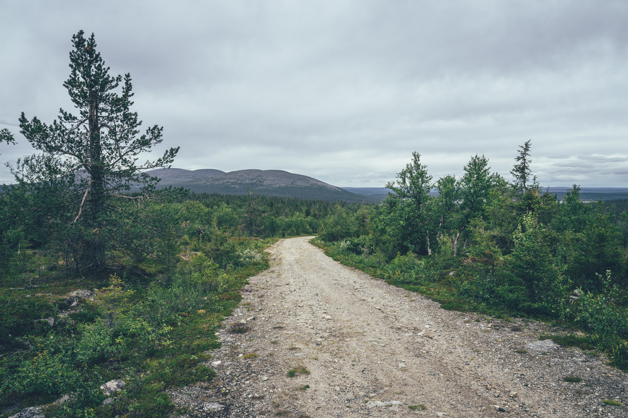
If the first three days on the route were mostly on pavement, the last two are finally on gravel on gravel on the famous Finnmark highland crossing on the old post road. The traffic-free varying condition 4x4 track is fantastic riding after a couple of days on the tarmac, going from lake to lake and pond to pond on and on across the arctic tundra. There are a couple of reindeer herding stations along the way, unused during summertime, but likely busy in early summer and in late September and early October.
The Suolovuopmi fjellstue is another of the full-service huts originally built and managed by the order of the King to serve the travelers on the post road. Nowadays the fjellstue serves as a café and restaurant, with multiple accommodation options available as well from a private room to small cabins on the hill next door.
Day 5, Suolovuopmi fjellstue to Alta City (55km, 700m of climbing)
The last part of the old post road has been maintained for tourism so it’s relatively smooth and therefore rideable with a normal car as well. The traffic is probably not too bad though, and most of the cars are probably moving slowly anyway, fascinated by the vast views of the arctic tundra of the Finnmark Highland.
Overall the day is excellent riding from start to finish, first on the scenic post road, then doing fun and high-speed descent to the valley, and finally approaching the Alta City on valley side recreational routes and seaside.