


Arctic by Cycle: Urho Kekkonen National Park MTB Loop
 131 km
 2-3 days
 1627m
1627m 473m
473m 85 %
85 % 44 %
44 % 4
4 100 %
100 %
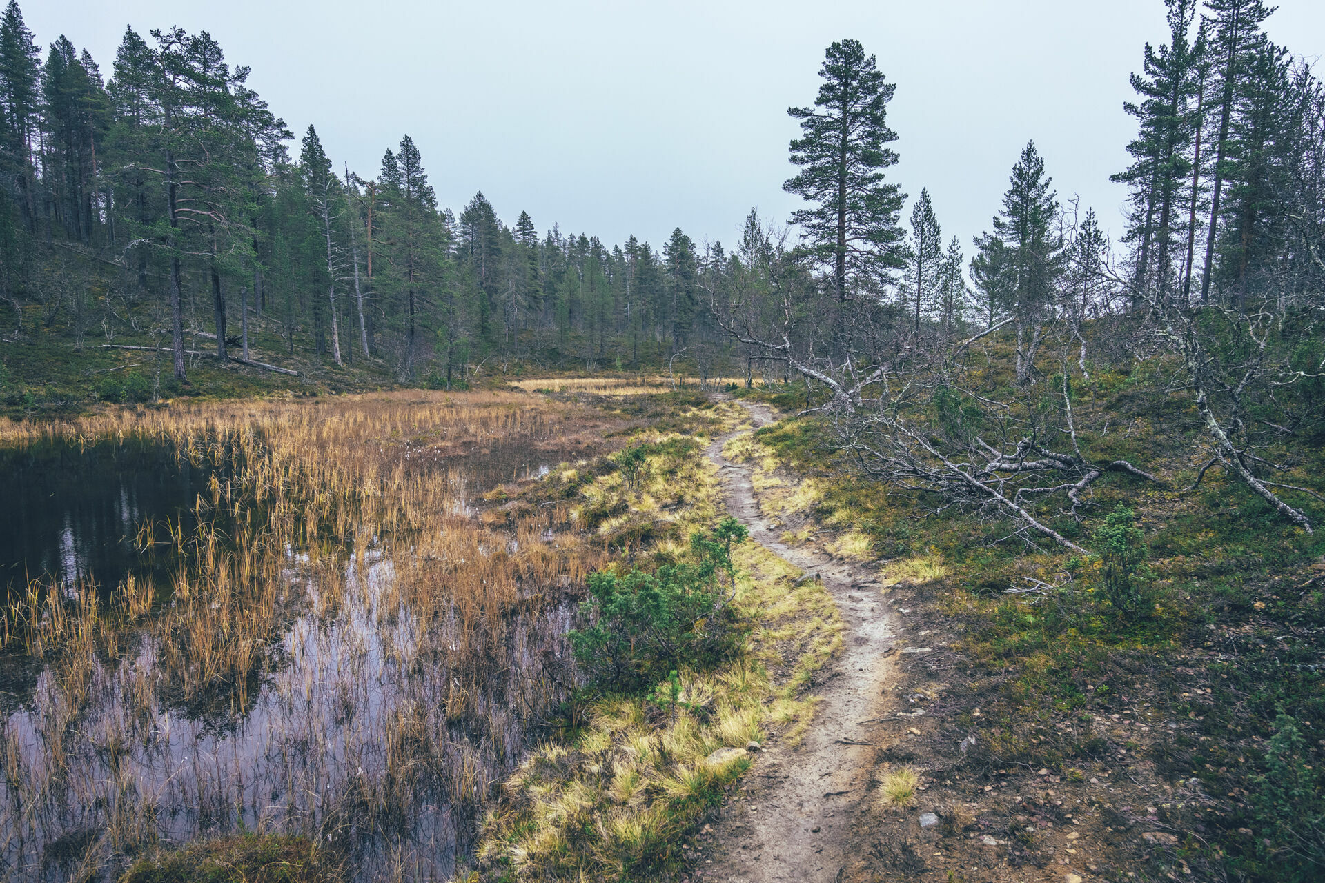
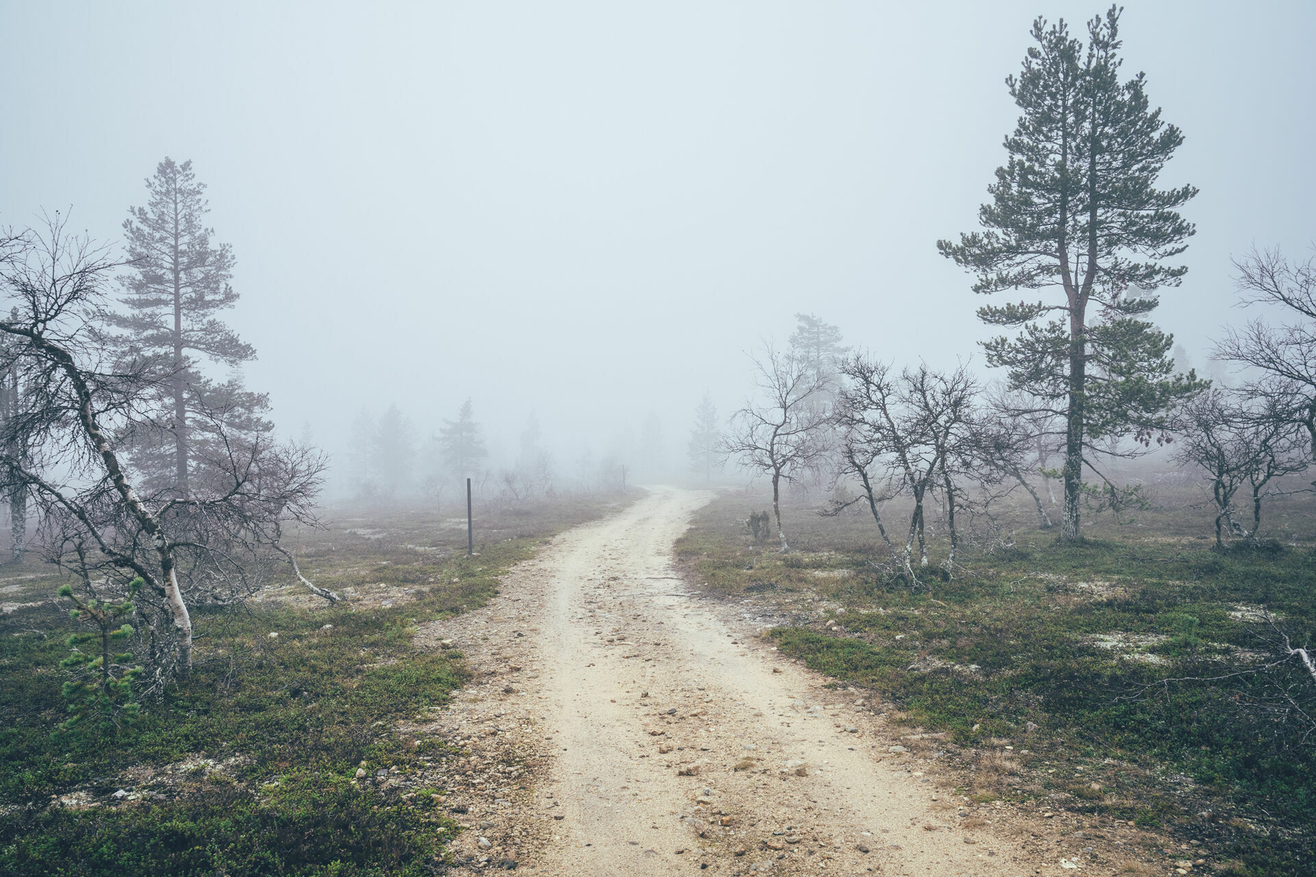
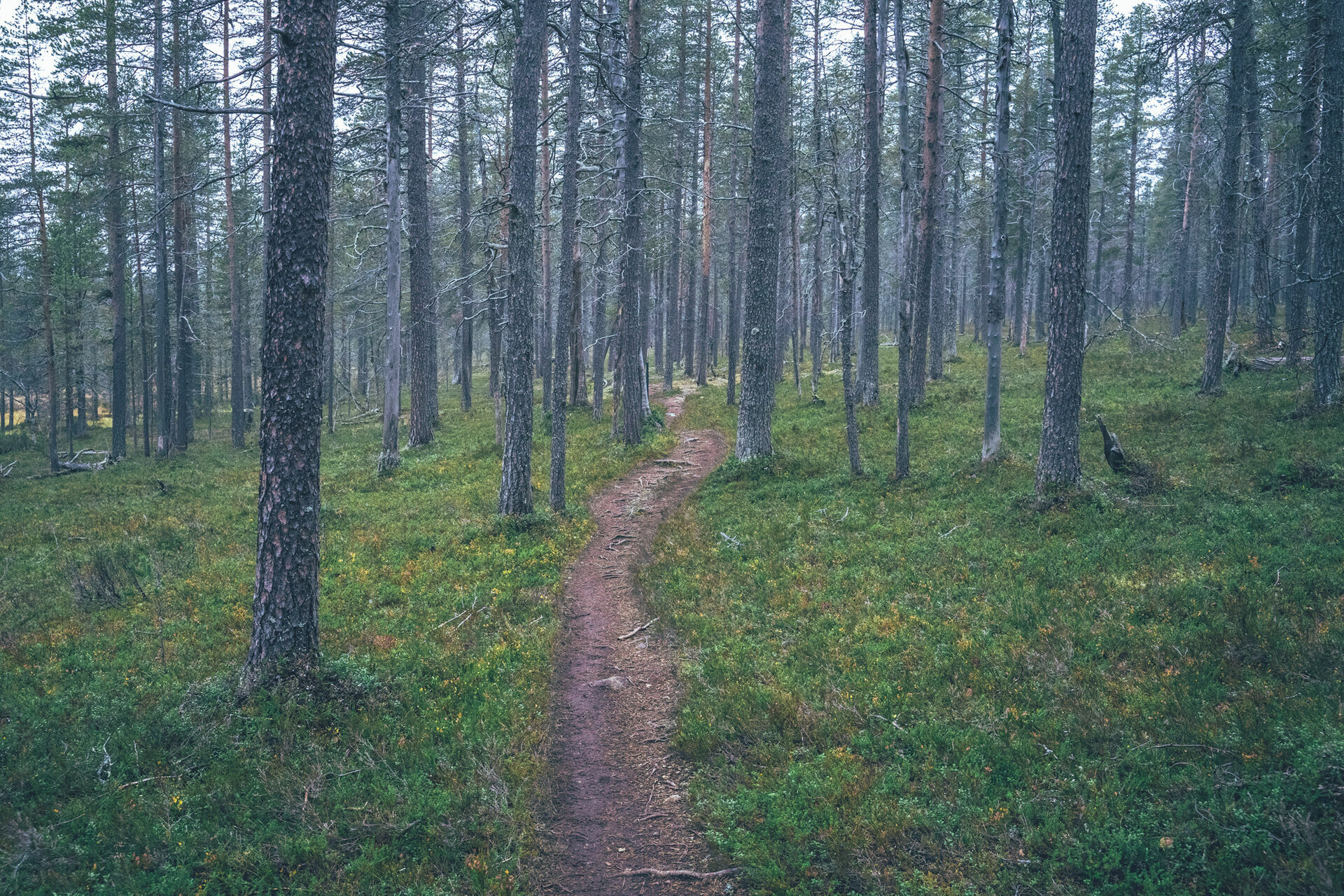
The Urho Kekkonen National Park MTB Loop is a 131km and 2-3 day mountain bike loop on the edges of one of the oldest and biggest national parks in Finland. The route starts from Ivalo via fast and smooth gravel roads to the northern border of the Urho Kekkonen National Park, where a 50km continuous single- and double-track starts across the western parts of the national park. The route is mostly easy riding on a mountain bike with occasional short more technical sections, keeping the riding interesting. Good riding, combined with some old, but well-kept wilderness shelters by qin clear rivers and creeks make the route a fantastic way to explore the nature and mountain biking trails of the Urho Kekkonen National park.
The Urho Kekkonen National park entails one of the highest and biggest fell areas in Finland and the second largest national park in Finland. A big part of the national park consists of endless fells above the treeline, giving the local mountain biking network its slogan “open fell biking”. The park has strict conservation policies which for now allow cycling mostly on the western part of the area, leaving the rest of the park for hikers.
Overall, the 2-3 and Urho Kekkonen National Park MTB Loop is a classic all-terrain bikepacking route, with multiple different gravel and dirt roads, smooth maintained trekking routes, and natural single track. The large proportion of single track pushes it easily into the mountain biking category and it’s ideally ridden with a mountain bike with front suspension, or any rig fitting at least 2.5” mountain bike tires.
- Over 50km of versatile single and quad track in the valleys, old-growth forests and fell tops of the Urho Kekkonen National Park in Eastern Finland
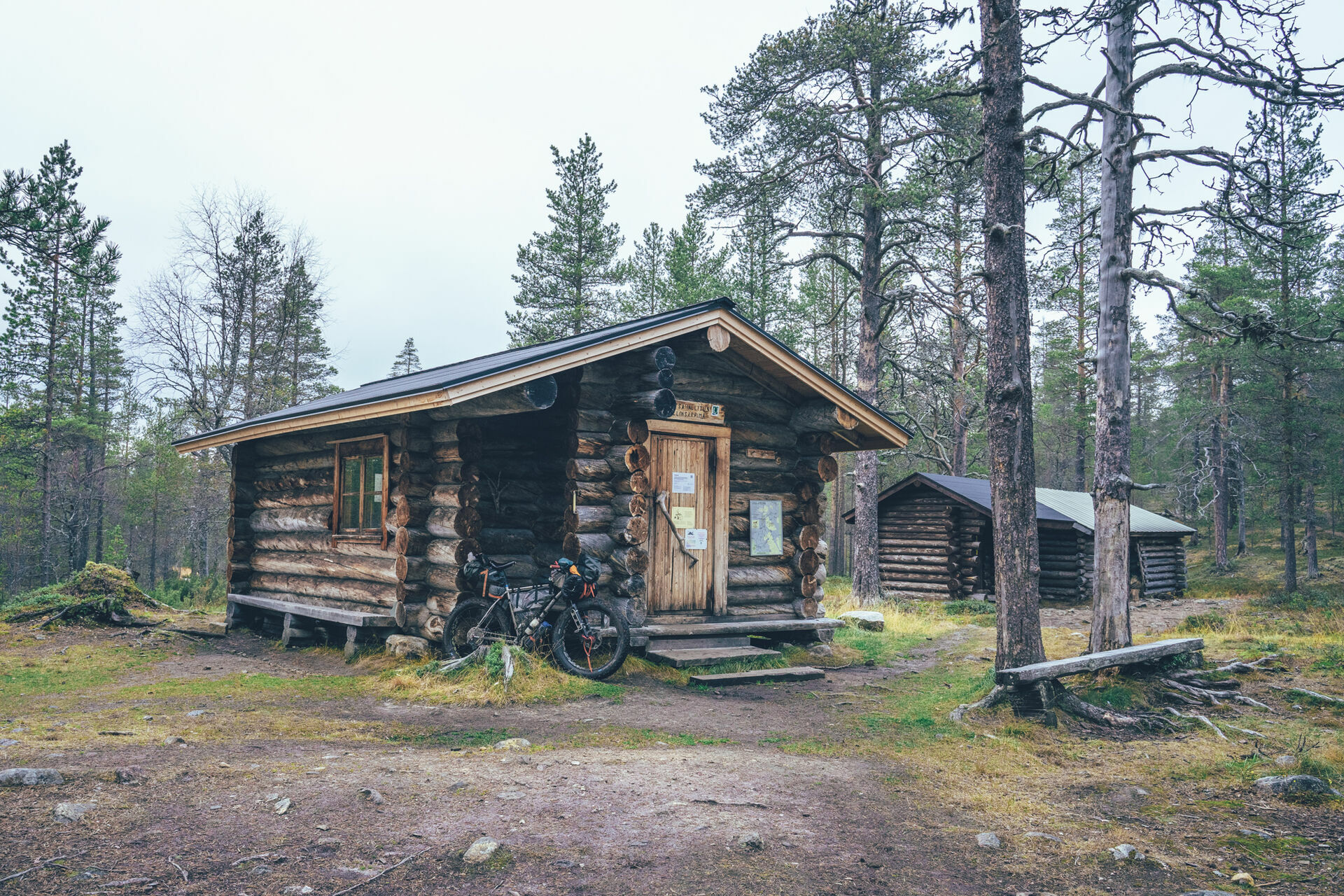
- 6 gorgeous wilderness shelters on the way, offering cover from the elements and a great spot to camp, usually by a crystal clear creek or river.
- High-level services are available in Ivalo, Saariselkä, and Kiilopää, making the route a perfect combination of wilderness and comfort
- Spot-on balance of more visited trails of the national park and rarely visited forest roads, where you're not likely to see anyone at all.
- Northern lights can be seen multiple times a week in autumn, if the sky is clear at night.
- The MTB routes in the arctic are usually rideable from early July, when the trails are dry enough to ride again after the winter, to early October, when the winter sets in again. However, the climate crisis makes seasons more unpredictable than before so the season start and end can vary year to year by a couple of weeks. There are no restrictions to the season requested by the local reindeer herding community.
- The infamous Lappish räkkä (the high population of mosquitos, black flies, biting midges and horse flies) starts usually by late June and lasts usually till mid August, making mid-August till October ideal time to ride the route.
- There are some reindeer gates along the gravel roads, which must be closed behind you if closed or left open, if open.
- The route is ideally ridden with a mountain bike with front suspension but can be just about ridden with any rig with at least 2.5” mountain bike tires. Small gears are highly recommended to make some of the climbs less strenuous.
- The route is doable with an e-Bike if you can do 60km of off-road riding with one charge between Ivalo and Kiilopää and on the way back to Ivalo you'll stop to recharge at Saariselkä as well.
- This not an Easy access route due to long stretches of narrow single track.
- Temperatures during the snowless season a lot and week-to-week but expect the spot-on daytime temperatures of 15-23 Celsius from mid-June to late August with nights in the range of 0-10 Celsius. Early June could be warm too but could be significantly colder as well. In late August and September, the temperatures start to drop significantly week by week and the first snow is not uncommon in late September. Especially late in the season, in late September and early October, be prepared for daytime temperatures of 5-10 Celsius and nights getting already below freezing.
- When choosing a sleeping bag, you should assume that the night temperatures can drop to 0 Celsius even during the mid-summer months and then even colder later the season gets. The classic -7 C/ 20 F sleeping bag works like a charm in Lapland, too, with the lower limit low enough for the late-season exploits.
- The midnight sun or “the nightless night” lasts from around 6 weeks in Southern Lapland to up to 3 months in Northern Norway. Getting used to the 24h sun can take a while to get used to…
- The best time to see the northern lights is roughly starting from September and as the nights get darker and longer towards the end of the season, chances are getting better week by week. It’s not uncommon to see the auroras multiple times a week at the end of the season, given that the weather gods are on your side and the sky is clear.
- The route has only digital navigation; for instructions and tips for successful navigation, see here.
- Always stay on the routes and aim to only use the recommended spots marked on the route map.
- The mobile phone network does not cover the whole route area: in case of an emergency, call 112 or use the 112 app, which automatically shares your location to the emergency services as well. It might be wise to carry a personal emergency beacon, especially when traveling alone.
- The route is located in a traditional reindeer herding area, please read more about the etiquette of traveling in the reindeer herding land here.
- Bears, wolfs and wolverines are not an issue at all when wild camping as the arctic predators avoid human contact to all cost. There are practically no encounters, ever. Therefore, there is no need to have a bear bell on handlebars, bear safe food containers or hand your food in a tree for the night.
- The worst of the mosquito season lasts usually from around mid-June to late August, though luckily cycling speed is usually fast enough to keep them away when on the move. During the peak times, a net hat and long sleeve shirt and pants are recommended, if the temperatures allow. As the temperatures drop, the mosquitos disappear, making September (if not also early June, if the roads are dry enough) an ideal time for touring.
- Great lodging options are available in Ivalo, Saariselkä, Kiilopää, and Kakslauttanen, making riding the route also possible without a tent - at least with some in-advance booking and confidence that you’ll reach your destination…
- 6 wilderness shelters on the route, offer fantastic camping as well. No other sites are allowed to use for camping in the Urho Kekkonen National Park, for conservation purposes. Expect to share the sites with other campers as well, the national park being one the of the most visited in Finland.
- Open wilderness huts and other wilderness shelters are a treat, but the rules of use are strict to make the system work. The last to arrive has the priority to stay overnight, so make space for people arriving after you. All the near-by-surroundings of the wilderness shelters operate as official camping grounds. To make the huts serve the most, it’s recommended to camp and use the hut only for cooking, socializing, and drying wet gear.
- Most of the recommended camping areas have publicly provided firewood available
- All the camp spots are next to a high-quality water source unless stated otherwise.
- There are grocery stores in Ivalo and Saariselkä, but also Kiilopää hotel has a small shop for basic groceries
- Multiple restaurants and café options in Ivalo and Saariselkä, but there is a restaurant at Kiilopää as well.
- Water is most of the time drinkable straight from streams, ponds, and lakes, but you never know if there is a reindeer carcass upstream, so better to be safe than sorry: water treatment is recommended.
- Sources of water are plentiful, so you’ll get away with carrying just 1 liter of water. The best spots for refills are marked on the route map.
- All the camp spots are next to a high-quality water source, unless stated otherwise.
- Tap water is always drinkable in Finland and locals are happy to fill your bottles
- When cooking in the camp, know that making a fire is strictly prohibited during the forest fire warming period. See the local restrictions here
- In terms of technical difficulty, the route gets 7/10 due to over 50km of single track, partly gravel-surfaced, but partly in the natural condition with rocks and roots. In terms of climbing meters, the route is one of the hilliest of the Arctic by Cycle Route Network with around 2300m of climbing over just 130 kilometers, and most of it on a single track, giving the route 7/10 as well for its physical difficulty.
- In terms of bikepacking challenge, covering the other areas such as the route difficulty (resupply, remoteness, lack of wilderness shelters, duration, etc.) the route is on the easier side with great services along the route, receiving a grade of 5/10. Despite that, we feel the route deserves an overall difficulty rating of 7/10, thinking of the high percentage of single track, especially. The trail can be ridden in both directions and it does not affect its difficulty. The route can also be started from Saariselkä or Kiilopää.
- The route is ideally ridden with a mountain bike with a front suspension but can be just about ridden with any rig with at least 2.5” mountain bike tires, preferably closer to the plus category. Small gears are highly recommended to make some of the climbs less strenuous. Bikepacking is usually the more comfortable the less you carry, and that also applies to this route due to the long single-track sections. As always, it's a treat to have small gears when touring, which makes some of the climbs of this route less strenuous.
- Traveling to Kiilopää, Saariselkä, and Ivalo can be done by first taking a train to Rovaniemi (multiple times a day, 8.5 hours) and then a bus (5 hours from Rovaniemi). You can book train tickets from vr.fi and bus tickets from matkahuolto.fi
- Ivalo Airport is located right on the route, and there are multiple flights a day (1.5 hours from Helsinki).
- In-advance booking of bicycles for the bus and train rides is likely to be necessary to ensure the bike fits in the cargo area.
- The route is connected to other parts of the Arctic by Cycle Bikepacking Route Network by connecting routes, either south to Central Lapland Gravel Loop or North to Teno River Valley Highway.
Day 1, Ivalo to Kiilopää (58.5km, 1290m of climbing)
The route starts from the Ivalo downtown on cycling lanes, before turning east to fast and smooth gravel roads, eventually leading to the Urho Kekkonen National Park after 31km into the day. Moitakuru day trip hut has a seasonal café for the high season months, making it a great spot for the break, before diving into the single-track hiking routes of the national park.
The first 7km are fast and flowy wide gravel paths down to the valley and the crystal clear River Lutto and Lutto day trip hut. Soon after that the natural single track starts and going gets significantly slower, though riding wise interesting as well. There are sometimes a couple of alternative single tracks to choose from, but the one marked on the map should follow the driest line of them. Taajos lean-to is located 47km from the start, and a fantastic place to camp and spend the evening by another crystal clear River Kulasjoki.
The most challenging of the single track end is only 5km later when the route joins a wide gravel-surfaced trail again, speeding up to progress. Luulampi day trip hut, with a seasonal café, is a nice spot for a break, before a steep 160m climb starts to the wilderness center of Kiilopää for the night.
Day 2, Kiilopää to Ivalo (72km, 1070m of climbing)
Day 2 starts with a gentle climb on eventually a treeless fellside to the day trip hut of Niilanpää, followed by a 6km and 200m downhill back lower elevation and pine-rich taiga. The services of Saariselkä are only around 23km away from Kiilopää, but the chances are you’re there around lunchtime anyway, given the 400m of climbing so far and the route being on natural single or quad track.
The last leg of the route is straightforward, the last single track-like section on the route being soon after Saariselkä, followed by varying condition forest and logging roads to the airport area and then back to starting point at Ivalo. In contrast to the middle section of the route, there are likely no people at all on the 35km remote section after Saariselkä, bringing some tranquility and peace to the otherwise busy route.