


 440 km
 5-8 days
 4575m
4575m 240m
240m 80 %
80 % 0.5 %
0.5 % 3
3 100 %
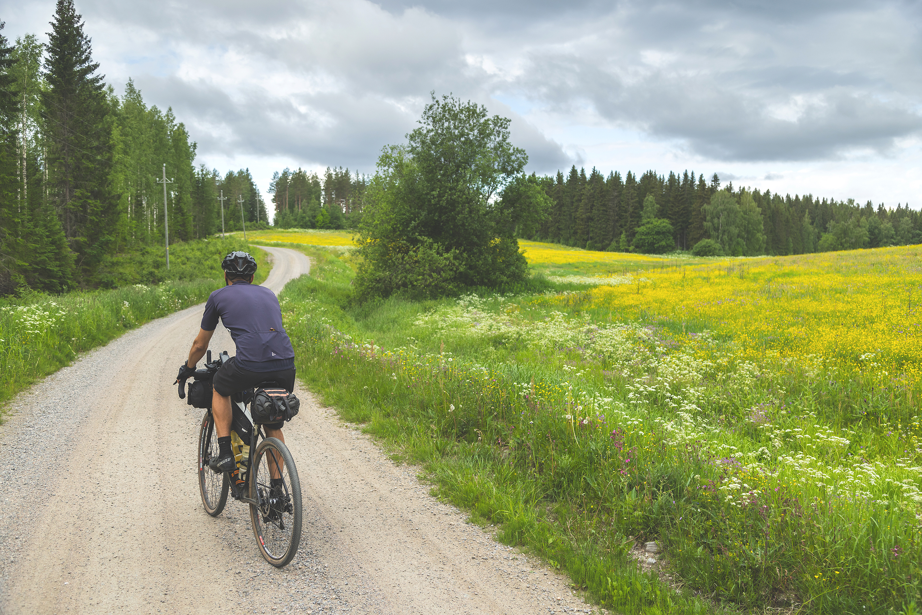
100 %The route starts from the train station in Jyväskylä and heads north towards Uurainen first along the recreational trails of Laajavuori and then to Tikkakoski via the lean-tos on the island of Nyrölä reserve. Most of the sand roads around Uurainen are great gently-rolling flow ones that lead to Multia e.g. via the Konttivuori nature reserve and the Karhunahdas ravine. From Multia, the route continues to Keuruu through magnificently verdant country landscapes. Further on, the route continues to Petäjävesi and to The Petäjävesi Old Church and to the old Lemettilä farm that provides accommodation nowadays.
From the church, the route goes south via Koskenpää and Halli toward Jämsä by the small but sweet nature reserve of Herajärvi. Before Jämsä, the route passes the Vororotti ravine dell and its hidden cave favored by highway bandits in the late 19th century. After the services on offer in Jämsä and Himos, the route follows the old Maakuntaura trail toward Korpilahti and Muurame still provides before Jyväskylä the best lake scenery of the week from the route atop the esker of Muurame.
Additionally to the great natural and historical sights, the unique and memorable services spice up the route. Services are available at fairly frequent intervals so touring stays rather light. Luckily there are 13 beaches along the route that provide opportunities for cooling off and lakes offer beautiful locations for breaks at regular intervals as well. The route can be ridden from guesthouse to guesthouse without a tent, at least if you book the nights well in advance. Though the route might be at it’s best by combining the best camping spots and the most interesting lodging options on the way.
From the point of view of physical difficulty, this route is more challenging than the other ones in Central Finland not only because of the overall ascent but because of slightly less frequent services too. A quicker rider can do the route a few days faster than specified in the Trail notes, though the elevation gain easily strikes up if trying to push the days longer.In 1763, Finland was under Swedish rule, and the Finns found themselves in a weak position vis-à-vis the Swedes. Gutsy and headstrong, they were considered more primitive and their language was found inferior, a state of affairs that, of course, did not please them. The residents of Petäjävesi obtained in 1728 already a permission from the Crown of Sweden to build a small village church yet the Crown had done nothing to further the matter over decades. The locals thus started work on their own accord and based on their own plans. The church has since then served Petäjävesi people in four centuries and is still in excellent, and nearly original, condition after repairs in the 1920s. In 1994, the Petäjävesi Old Church was listed as a UNESCO World Heritage Site as a unique example of the long-standing tradition of Nordic wooden church architecture and timber construction. It is situated in the village of Petäjävesi next to the Lemettilä farm that has been inhabited since the 17th century.
People have commuted to the Old Church of Petäjävesi using the old village-to-village and farm-to-farm commuting routes for 150 years already. Majority of the old routes and roads have been turned into larger paved routes and highways, though there are remnants of the old main roads here and there left on eskers, side roads and current cabin access roads, which occasionally still can be linked up to a scenic and historic cycling routes. These roads also form the backbone of the 442km and 5-8 day Old Church Grave Loop
- The Old Church of Petäjävesi is an UNESCO World Heritage site and one of the most valuable remaining log churches
- The wide range and frequent services makes bikepacking light and easy
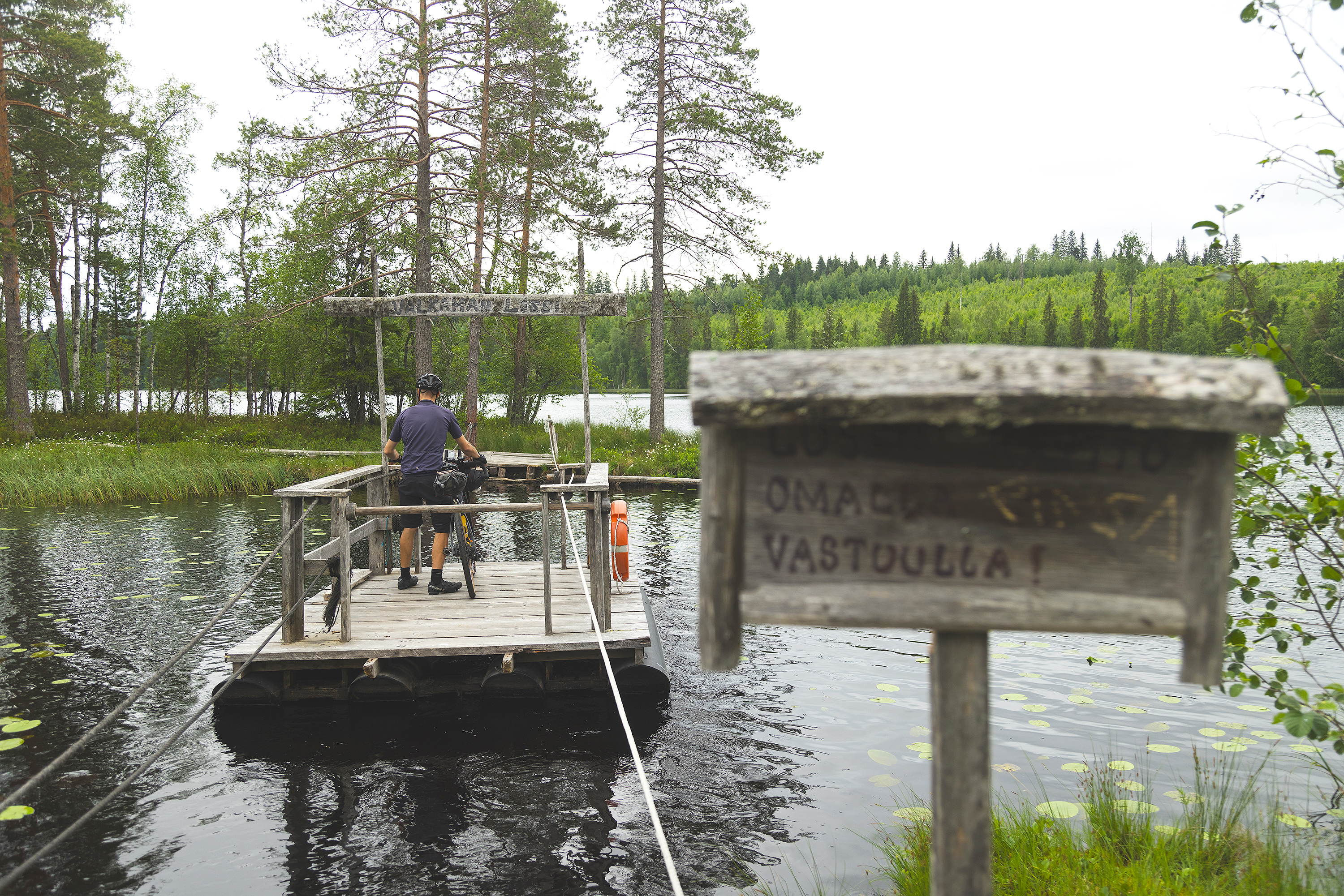
- The lean-to island of Nyrölä after a jaunt on a rope-pulley ferry
- The Karhunahdas and Vororotti ravines
- Herajärvi nature reserve offers a glimpse of old-growth forest and crystal clear lake
- 13 beaches strewn at regular intervals along the route
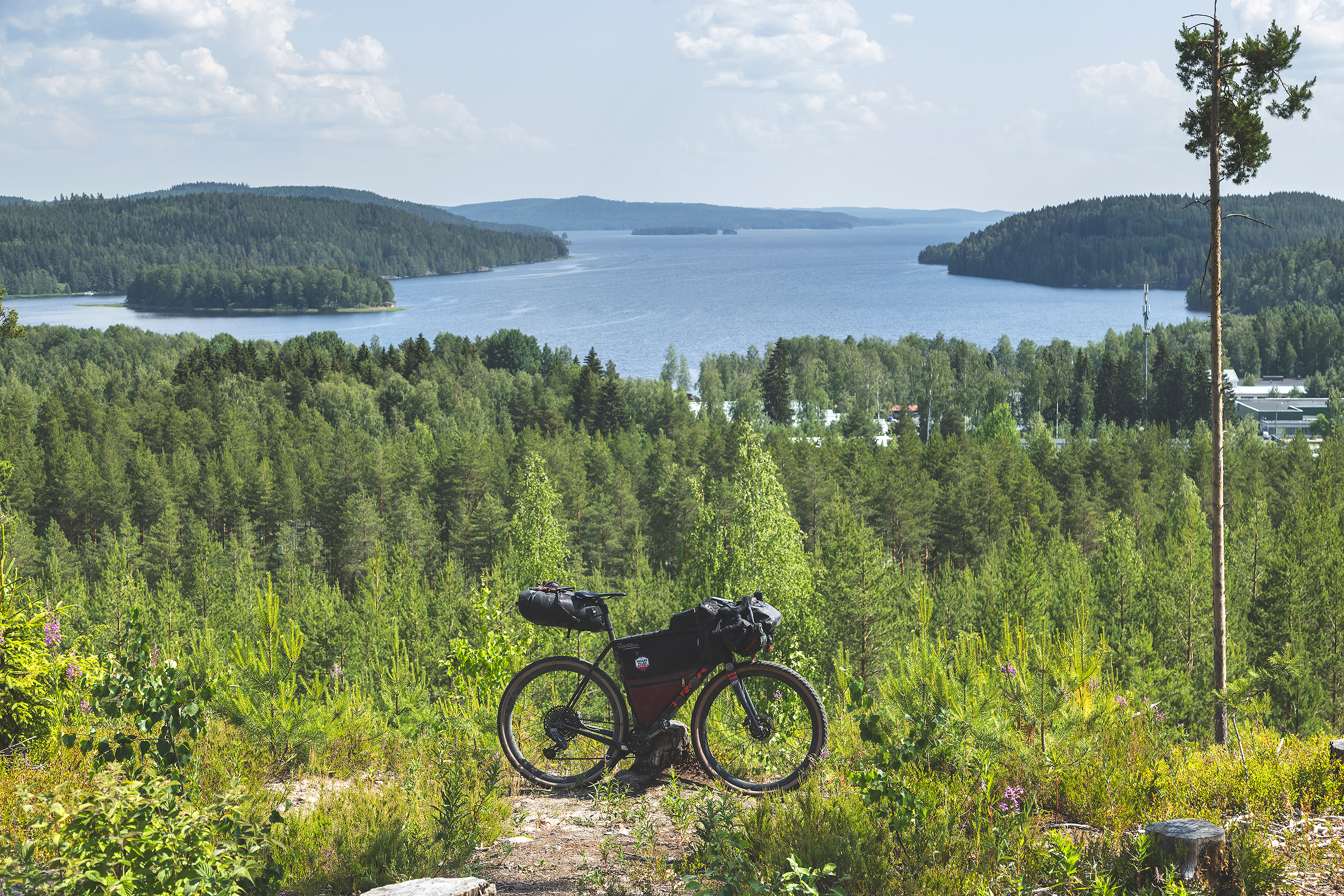
- The esker trail in Muurame with it’s scenery far into the blue horizon
- Gently rolling flowy gravel roads from village to village and from service to service
- The idyllic and unique guesthouses and farm accommodation options offer interesting overnight experiences
- The route can be ridden on any bicycle with a minimum tyre size of 35mm yet the bigger and the better here. Of all the Lakeland by Cycle routes, this has the coarsest road surfaces.
- The best season for bikepacking in the southern part of Central Finland is usually from late May to late September. The day temperatures are within a 12-to-20 degree bracket in early and late summer and between 15 and 25 degrees during summer months.
- When selecting a sleeping bag, it is a good idea to assume that night temperatures can drop well even below 10 degrees at least in the early and late summer.
- The route has digital signage only. Please read the instructions and tips at bikepacking.com for successful route plotting here and here.
- Always stay on trail and try to use only the campsites and break locations recommended in the route description. In addition, follow the Metsähallitus Outdoor Etiquette and the Outdoor Association of Finland’s Mountain Biking Etiquette.
- The entire route area is covered by a telephone network: help is always available by calling the number 112 or via the 112 app.
- Water supply points are often far from each other on the route so be sure to have enough water-carrying capacity at hand especially in summer heat. A minimum capacity of 2L is recommended while a larger one does not hurt either.
- The route can be ridden without camping equipment at a daily progress as indicated in the trail notes when overnight stays are booked in advance.
- The prices of accommodation services vary but the quality-price ratio is usually excellent.
- Camping is permitted and free of charge at all of the campsites marked on the map with the exception of those camping areas and services that are subject to a fee. Some of the campsites subject to a fee are situated in connection with accommodation services.
- As a rule, drinking water is not available at the recommended campsites so carry the water for the night from the nearest water supply point.
- Firewood and outhouses are available at only some of the break and overnight locations.
- There are AirBnB accommodation alternatives along the route but their availability varies.
- Restaurants, cafés, and shops can be regularly found along the route but the opening hours of services especially outside population centres may vary a lot from season to season. Check out their opening hours in advance. The restaurants, cafés, and shops are also among the most important water supply points of the route.
- Usually, the route can be managed by carrying provisions for one day and two litres of water. However, one is more likely to need to carry more water for an overnight stay, and even more may be necessary between water supply points during periods of hot weather. A three-litre drinking water carrying capacity reduces significantly the risk of running out.
- At leans-to and shelters, it is essential to remember that making an open fire is absolutely forbidden when a forest fire warning is in effect. For information about regional forest fire warnings, click here.
- As a rule, drinking water is not available at the recommended campsites so carry the water for the night from the nearest supply point.
- Tap water in Finland is usually of high quality and suitable for drinking. The roadside restaurants, cafés, kiosks, and shops are happy to fill riders’ bottles.
- Lake water can also be used for drinking or cooking but only if it is purified first.
- A good deal of the route is on easy and flat gravel and forest roads but there are some coarser and softer sections too. There are no unrideable sections, but a couple short single track sections might need basic mountain biking skills. Though they are very short and pushing your bike through takes no time at all. The paved roads, gravel roads and single track sections are marked on the route map with color coding.To find out more about the difficulty gradings in the route map, click here.
- The route is physically demanding at times due to some rollercoaster-like sections of gravel road but the hills are often short. Compared with the other Lakeland by Cycle routes, the services along the Old Church Gravel Loop are a little less frequent as can be seen from the longer and more taxing daily legs if one goes from guesthouse to guesthouse. With the pace suggested in the trail notes, there are a couple of days with more than 1200m of climbing, which starts to be a proper day on a bike. Fortunately, there are lots of lean-tos and other shelters functioning as recommended campsites, so you can easily pace your progress based on your fitness, available time and weather conditions. Though slower you go, further the stock-up points are time-wise, as always. Especially the needs for water carrying capacity increase 1:1 when slowing down from suggested pace in the Trail notes. From the point of view of physical difficulty, the route rates as high as 7/10 while its technical difficulty is 4/10.
- In terms of bikepacking challenge the route is overall an easy one as there are services at fairly regular intervals anyway. The only challenges are how to carry enough water and how to reach the next services in order to replenish water supply during their opening hours.
- Thanks to the public transportation network in the Jyväskylä region, getting back to Jyväskylä from various parts of the route is easy if the trip comes to a premature end or if one just wishes to ride it in parts. Among the services, only the bike maintenance spots are fewer and further between, and solving major problems may force a cyclist to return to Jyväskylä. As a bikepacking challenge, the route rates as 5/10.
- The route can be ridden in both directions and the direction of travel does not affect its difficulty. The overall difficulty level of the route is ranked 6/10 so it remains a fairly doable one in spite of the physical challenge that it represents.
- Bikepacking is usually the more comfortable the less you carry, and that also applies to this route, at least partly.
- On the other hand, riding is non-technical, so apart from the few short sections, the route is completely doable with a traditional rack & pannier setup as well with whatever gear you happen to have. As always, it's a treat to have small gears when touring, which makes some of the climbs of this route less strenuous as well.
- Bikepacking is often the more comfortable the lighter the equipment is and the less you carry, which is partly true on this route given its rollercoaster-like character. A full-on bikepacking setup is a lighter and more aerodynamic way to go, but you’ll probably have fun with whatever gear you happen to have strapped on your bike, at least if you have small enough gears.
- The recommended minimum tyre size is 35mm due to occasional coarse gravel and a couple of softer sections but an experienced rider will be alright with even skinnier tyres too. On the other hand, tires larger than 35mm will increase comfort and are not likely to slow progress much at all.
- There are excellent train and bus connections to the starting point of the route at Jyväskylä from nearly everywhere in Finland. Advance booking of a place for a bike on a train well ahead is recommended, though luckily there are dozens of trains a day.
- The train stations of Petäjävesi, Keuruu, and Jämsä are also situated by the route.
- There is an excellent bus connection to Jyväskylä from nearly every major village on the route.
Day 1: Jyväskylä – Marjoniementila (69km, elevation gain of 900m)
NB! Fill up your water bottles before you leave Jyväskylä since there are more than 40km to go before the next secure water supply point in Tikkakoski!
The Old Church Gravel Loop begins from Jyväskylä on paved cycling paths but soon switches to the recreational trails of Laajavuori that vary between gravel paths and forest roads. After Laajavuori, the route crosses the Keuruuntie road a few times (the main road of the region), before heading north toward Tikkakoski and away from the main road.
The journey toward the lean-tos on the island of Nyrölä, an excellent location for a break, continues on narrow and peaceful gravel roads. The island is a bit off the route but well worth a detour especially if one is in the mood for cooking a lunch. A signposted route on a wide forest roadbed followed by a short duckboard section leads to the rope-pulley ferry that goes to the island. There are a combination of several lean-tos, a campfire site, and a jetty on the island.
10km after the lean-to island, one arrives in Tikkakoski where restaurants and shops await. From the village of Tikkakoski, the route continues on the eastern shore of Lake Luonetjärvi on recreational trails that vary from single track to ski trails and small gravel roads. The beautiful location of the lean-to in Peuraniemi along the way is an excellent spot for a break.
The roadbed of the recreational trail north of Luonetjärvi consists of clay sand that is smooth when dry but can be slippery when it rains, though luckily the section is not too long and the route soon joins the next stretch of hard-packed gravel. There is a sizeable horse farm northeast of Luonetjärvi and a lot of horseback riding in the area so watch out for eventual encounters with horses. When meeting one, it might be best to slow down and even go to the roadside letting the rider and it’s horse to pass you by, unless instructed otherwise.
The smooth gravel roads continue towards Uurainen deep in the forest between occasional forest cutting areas and fields. The beautiful and cosy surroundings of Uurainen with its services are an excellent end point for the day. Though continuing a little further, a very beautiful gravel road connection to the services of the Marjoniementila farm rounds up the day.
Day 2: Marjoniementila – Camping Sinervä (62km, elevation gain 1,200m)
The second daily leg starts from the Marjoniementila farm with a ca. 5km asphalt road connection to the west of Lake Kyynämöinen. After that, there is a rolling and flowy gravel road on which some traffic may occur in the holiday season. Along the road, there are the Huutoniemi beach, the mightily thick Esan petäjä pinetree, the old mill of Sivula, and the small nature reserve of Konttivuori. The Hietajärvi camping area is also by the roadside.
The good flow continues on gravel road to the small village of Höytiä with a charming and very clean lean-to in the centre. A perfect location for a break. The route continues on gravel roads in good condition but please note that there is forestry in the area and that the road condition may vary.
There are two magnificent nature sites on the way from Höytiä to Multia at the end of the daily leg: the Talkoovuori lean-to and nature path and the protected Karhunahas ravine with its lean-to. The ravine is especially worth a visit since it is right next to the route only a couple of hundred metres from the gravel road.
The daily leg to Multia and Camping Sinervä is a short one but the altitude changes and the well-kept gravel roads make for an interesting ride that is physically even more demanding than the first day.
Day 3: Camping Sinervä – Iso Kirja Camping (40km, elevation gain 570m)
The third daily leg starts from Multia with a short 3km section of asphalt road but the route soon leaves the paved Petäjävedentie road and heads for the gravel roads deep in the forest. The gravel roads almost all the way to Keuruu comprise easy stretches in good condition with moderate changes in altitude.
The gravel roads go through idyllic farms and field clearings. It is especially when the summer season is at its most verdant, that the route offers magnificent country landscapes. At the 100km mark of the route, you find entertainment in the middle of a forest and can try your hand at horseshoe-throwing. A small set of instructions tells you how to score points, and you will find both the horseshoes and the target on the ground below the instructions. From the throwing site, the route continues as a nice forest road where the top scorer sets the pace.
One arrives at Keuruu on the old Maakuntaura hiking and skiing trail that cuts through the old province of Central Finland. The Maakuntaura is in many parts forgotten but some of it now entertains bikepackers in Central Finland. Its high points include the lean-to of Lake Valkeinen and the fine rock trail that starts from there. Please note that the trail on the base rock can be slippery when it rains.
The Maakuntaura soon leads to the centre of Keuruu with a train station in addition to the usual services. There is a wide variety of restaurants, cafés, and shops. It is a good idea to replenish equipment if need be at the well-stocked service centre before hitting the road connection to the Iso Kirja Camping area about 4km from Keuruu. Most of the distance is on asphalt road. The camping area is the biggest in Finland so there is ample space for tents in addition to other accommodation alternatives.
The third daily leg is short in comparison with the two preceding ones in terms of kilometres but it includes close to 600m of ascent nonetheless. It takes another 33km and another 600m of ascent to reach the services in Petäjävesi should one be in the mood to get going.
Day 4: Iso Kirja Camping – Kievari Rantapirtti (53km, elevation gain 970m)
The fourth day of the Old Church Gravel Loop starts from the campsite on a beautiful, narrow, and gently rolling gravel road towards the Petäjävesi village. The route follows a gravel road in good condition deep in the woods all the way to Petäjävesi. The leg from the Iso Kirja Camping is a relatively long one and has no roadside services. There is an elevation gain of 600m on the 30-plus-kilometre way so the section is slower to ride than you would think.
As one reaches Petäjävesi, the route goes by the old log church listed as a UNESCO World Heritage site so the impressive old sanctuary is worth a visit. You will find the services that you need such as food shops and restaurants in the centre of Petäjävesi. The Maatilamatkailu Kumpunen resort whose grounds and accommodation services make for a fine experience is also situated close to Petäjävesi.
The route continues south towards Koskenpää in the midst of splendid lake scenery. The section across the narrow peninsula between waterways is particularly beautiful!
The route continues as a gravel road in good condition all the way to the population centre of Koskenpää.
NB! If you head to the Kievari Rantapirtti guesthouse for the night, please note that it is a bit off the track 5km north of Koskenpää by the main road. One gets there either via the services in Koskenpää and then “back tracking” 5km north on the main road or leaving the route already north of Lake Pettämäjärvi along the Sahloisten rantatie road 5km to the south on the main road.
Day 5: Kievari Rantapirtti – Villa Klubiranta (70km, elevation gain 780m)
The fifth daily leg includes a longer section with no roadside services so it is a good idea to restock food and drink supplies at the place of accommodation or in the Koskenpää village. From there, the route continues via a short asphalt connection to the beautiful Survosenkoski rapids for a break. After the rapids, there is a more remote area with 35km of gravel road with no services. Most of the roadbed is fast and hard-packed gravel. Along the route towards Halli, there is e.g. the Hattula Art Farm, a site worth a visit but open only by appointment.
After Hattula, the route swings by the nature reserve area of Lake Herajärvi. There is a lean-to and a fire ring. On hot days, the premises offer an excellent opportunity for a refreshing dip. From the lake, the route returns to a bigger gravel road.. The Herajärvi loop may have occasional stretches of fine sand so narrow tyres might mean slow going occasionally.
The route continues from there toward Halli village on a bigger gravel road, which is mostly fast riding. Apart from the clear-watered creek between the Jämsänjärvi and Liesjärvi lakes, there are no water spots along the way. All natural water should, however, be purified as a rule. If a break is needed, the Likolahti beach and campfire hut are there about 15km before the end of the daily leg. The village of Halli is a small one but has all the services needed by a bikepacker with the exception of a bicycle repair store.
Day 6: Villa Klubiranta – Countryside Hotel Morva (65km, elevation gain 915m)
From the centre of Halli, the sixth day starts with a short section on asphalt but continues on a gravel road after a few kilometres. What lies ahead is yet another longer stretch without services so it is important to restock on food and drink here.
The gravel road that starts around Halli is a quiet one and mainly deep in the forest. It ends by the very heavily trafficked Tampereentie road on which the route goes on for about 500m before continuing on a gravel road on the opposite side. Be careful when you cross a road under heavy traffic.
The route leaves the Tampereentie road and gets back to a quiet gravel road. Its quality varies a lot, and there is coarse rough gravel for about 4km. Be careful when you ride this section! The reward comes in the form of the magnificent courtyard area of Köntti and of a section of the old Laukaantie road. Get to know some history on the courtyard and study the old road signs.
The route continues nicely from the Köntti courtyard with altitude changes while the roadbed remains good and fast. The route crosses the Tampereentie road for a second time and goes by the cafeteria of the Alho Felt Factory and the Juvenkoski waterfalls. Both are worth a visit. Soon afterwards, it is paved roads downhill to the services in the centre of Jämsä.
From Jämsä, the route continues on the shore of the Viianlahti bay and follows a paved road to the ski resort of Himos. After Himos, it joins once more for a while the Maakuntaura trail, most of which are gravel and forest roads here. The cooking shelter by Lake Syväjärvi is a splendid place for a break; however, the Countryside Hotel Morva at the end of the daily leg is only another 7km away.
Day 7: Countryside Hotel Morva - Jyväskylä (74km, elevation gain 1,190m)
The last leg from Morva to Jyväskylä offers plenty of variation in terms of both road bed and scenery. The route starts on gravel roads and follows the side of Highway 9 for a while. Fortunately, there is no need to go on the highway. The route leaves the edge of Highway 9 and features a good deal of ascent before going downhill towards the population centre of Korpilahti.
Korpilahti has a beautiful harbour area that is worth a visit on a beautiful summer day. There is a restaurant in the harbour, and other services including shops are handily situated along the way. From Korpilahti, the route takes the beautiful sinuous gravel roads back to Highway 9 and crosses it safely via an underpass.
What lies ahead after the underpass is one of the highlights of the last leg: the esker trail of Muurame. It starts going uphill in a gorgeous esker landscape first as a wider sand road and soon afterwards as a narrower trail. The trail is rocky at times but remains wide enough to avoid stones, and there will not be any spots too difficult to navigate even with a loaded bicycle. Attention is required however.
What opens up from atop the high esker is one of the most breathtaking landscapes along the route. Large waterways reach to the horizon, and forests and hillocks enrich the scenery. It is like watching a painting. There are several trails criss-crossing the esker so be careful and follow the GPS track to stay on the right one.
There is a descent from the eskers into the centre of Muurame where the route follows a beautiful gravel-covered nature trail along the Muuramenjoki river. There are several nice spots along the trail to stop at for a breather. Finally, the route crosses the river over a small bridge.
The rest of the leg from Muurame to Jyväskylä is on a variety of roadbeds. After Muurame, the route follows a green corridor on a narrow trail with an excellent even surface. The occasional changes between cycle paths and gravel roads will go unnoticed.
Before Jyväskylä, the route goes under Highway 9 and moves to the Jokipakantie road. Please note that there is a 90-degree turn in the Jokipakantie downhill slope so that you can get to the recreational trail to the Keljonranta beach. You ride a while on the Keljonrannantie road until a tight turn to the right. You may pass the crossroads without noticing it so watch out for it.
The route goes heavily uphill from the corner of the golf course and snakes around the recreational trail in good condition. The trail winds its way in a nice forest landscape until it finally meets the cycle paths near the centre of Jyväskylä. It still goes around the shore of Lake Jyväsjärvi to Mattilanniemi and along the lakeshore route to the courtyard of the travel centre.